First, the industry background
The solar photovoltaic power generation system is mainly divided into centralized and distributed. The centralized power station generally covers a wide area, mostly built in the northwestern part of China and some remote areas. The natural environment is relatively harsh, such as large-scale northwest terrestrial photovoltaic power generation system; On the roof, greenhouses and large-scale pools, such as industrial and commercial enterprise roof photovoltaic power generation system, residential roof photovoltaic power generation system.
However, these photovoltaic power plants have brought a lot of operational and maintenance pressures after grid connection, such as conventional equipment testing and photovoltaic panel inspection. The traditional operation and maintenance method adopts manual inspection, which is inefficient, and the equipment fault diagnosis is based on the experience of the operation and maintenance personnel. It is easy to produce leakage and deviation; and in the harsh natural environment of remote areas, the inspection of the vast photovoltaic power station It is very difficult and dangerous. For photovoltaic areas such as agricultural light complementary, fishing light complementary, and rooftop power stations, traditional manual inspection cannot meet the demand, and it is impossible to achieve safe and efficient PV inspection purposes.
Second, the program objectives
The drone is equipped with a visible light camera, a thermal infrared sensor or an EL detecting device, and collects visible light, thermal infrared image or EL data of the photovoltaic component to realize intelligent inspection of the drone, and improve the efficiency and safety of the photovoltaic inspection. The visible light and thermal infrared images are stored in real time and can be quickly exported to the pc end. The UAV intelligent diagnostic software is used to intelligently process the thermal infrared image and the visible light image collected by the drone to realize the component non-power generation detection, dust and dirt blocking, Automated diagnosis and localization of hot spots caused by failure of components such as cracks. Greatly improve the inspection efficiency of the photovoltaic power station and the accuracy of fault diagnosis.
Third, the introduction of the drone inspection system
The UAV inspection system includes four parts: the UAV system , the data acquisition system, the ground intelligent control system, and the data analysis and processing system. As shown in Figure 3-1
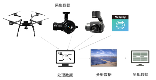
Figure 3-1 UAV inspection system
1 , the drone system
The UAV system is equipped with an ultra-long-time, industrial-grade multi-rotor U100 with IP56 protection and the latest DJI A3 flight controller with fully optimized attitude analysis and multi-sensor fusion algorithms for precise and reliable integration. High-definition image transmission, real-time view of the camera screen, transmission distance of up to 5 kilometers, picture transfer quality 720P; built-in intelligent battery management system, real-time monitoring of remaining battery power, the system will automatically analyze the calculated amount of return and landing power and Time to avoid the danger caused by insufficient power. At the same time, the 20-minute fast charging function can be realized, and the battery can be fully charged in a short time. The system parameter table is as follows:
project | parameter |
Flight platform | M6 |
Wheelbase | 805 mm |
Maximum load weight | 4.5kg |
GPS hover accuracy | Vertical: ±0.5 m; level: ±2.5 m |
Maximum rising speed | 5 m/s |
Maximum falling speed | 3 m/s |
Maximum speed | 18m/s |
Maximum wind speed | 10 m/s (sixth level) |
Maximum flight time | 50min |
Â
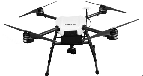
Figure 3-2 UAV System M6
2 , data acquisition system
The data acquisition system includes visible light collecting obstructions, dust covering conditions, and infrared cameras collecting hot spots. The visible light integrated PTZ camera X5 and the thermal infrared integrated PTZ camera XT are separately arranged. The X5 combines a new image sensor with a powerful processor to capture 4K/30p video and 16 megapixel photos. The XT thermal imaging camera uses a range of FLIR proprietary technologies to reflect subtle temperature differences and make the target clear at a glance. The system parameter table is as follows:
project | parameter |
Visible light camera | X5 |
Pixel | 16 million pixels |
Photo maximum resolution | 4096x2160 |
ISO range | 100~25600 |
Video resolution | 4K |
Video format | MP4/MOV |
Thermal infrared head camera | XT |
Resolution | 640 × 512 |
Lens | 19 mm |
Minimum focal length | 15.3 cm |
Scene range (high gain) | -25°C to 135°C |
Scene range (low gain) | -40°C to 550°C |
Point temperature measurement | Center 4×4 temperature measurement |
storage | Micro SD card |
Photo format | JPEG, TIFF |
Video format | MP4 |

Figure 3-3 Visible light integrated PTZ camera X5 Figure 3-4 Thermal infrared integrated PTZ camera XT
3 , ground intelligent control system
The ground intelligent control system can realize autonomous route planning flight and can save on multi-task routes, making complex inspection work easier. As shown in Figure 3-5:
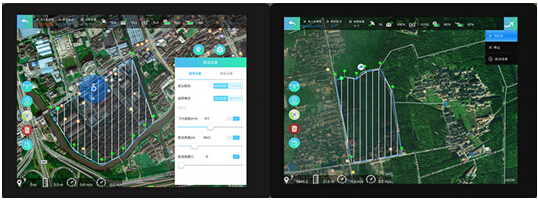
Figure 3-5 Autonomous route planning
4 , data analysis and processing system
Data analysis and processing is the key to the entire system. The data collected by the drone is multi-dimensional and fragmented. Users can get the large amount of scattered data and can't directly find the problem. The software can analyze and process a large amount of scattered data to generate a complete data report, including length, height, angular size information, component hot spot temperature information, etc., so that users can more clearly and intuitively understand the status of the survey area. As shown in Figure 3-6:
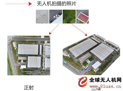
Figure 3-6 Data Analysis Processing System
Fourth, the application case
On June 15, 2017, Shanghai Bolei Intelligent Technology Co., Ltd. carried the self-developed UAV inspection system to perform hot spot detection for the distributed power station of Zhejiang ** factory. The PV modules are distributed on the roof of the factory building. The overall situation is shown in Figure 4-1. The capacity of the roof power station is 400KW and the data collection time is 30 minutes. The general process is:
(1) Site survey: The drone is equipped with a visible light camera, and the base survey is first carried out on the factory.
(2) Automatic route inspection: The drone is equipped with a thermal infrared camera, and the ground station automatically plans the flight route to collect infrared data;
(3) Software analysis and processing: The infrared data uploading software collected by the drone is processed and analyzed to generate a thermal infrared temperature information overview map, which visually displays the hot spot distribution of the measurement area and locates the specific location of the hot spot of the photovoltaic component. .

Figure 4-1 Overview of distributed power station
Through the intelligent flight of the drone, the visible light and infrared thermal imaging temperature data are collected, the hot spot position map obtained by the software intelligent analysis and the position map indicating the hot spot temperature are shown in Figures 4-2 and 4-3. , where the position map is presented in the same direction as the map (upper north, lower south, west west, right east).
Â

Figure 4-2 Hot spot effect diagram
Â

Figure 4-3 Hot spot temperature effect diagram
Five, program advantages
The advantages of UAV inspection system in the field of photovoltaics are reflected in:
(1) The inspection speed is fast and the efficiency is high, especially for large centralized power stations;
(2) It is not restricted by the topographic environment, and is especially important for agricultural light, fishing light complementary and rooftop power stations;
(3) It is easy to operate and has high safety. It can be started in two minutes and fully autonomously flying;
(4) The cost is lower, and the benefit can increase the electricity production;
(5) Diversification of loadable equipment to achieve multi-functional, multi-purpose testing;
(6) The body is light and easy to carry.
This scratch-resistant TPU Film protects your new AirTag from daily wear and tear. It can be easily glued to the back to keep the shiny silver in its original condition. In addition, the AirTag screen protector with "self-healing" function can automatically repair small scratches and bubbles within 24 hours. This means you can continuously enjoy the new look and appearance of AirTag without worrying about serious scratches and dents.
The Apple Airtag TPU Film can perfectly fit your AirTag skin. It is designed to provide the maximum coverage for your AirTag metal panels. Compatible with most AirTag shells. Leave extra space around the frame so that your shell can wrap the edges of the AirTag without interfering with the film.
The 0.14mm ultra-thin AirTag Screen Protector allows you to enjoy the maximum resolution while being thin enough to make the AirTag sensitive to the original signal response, ensuring that it will not affect any user experience. You won't even notice that the screen protector is there, so your Apple logo can still be displayed.
The AirTag Tracker Screen Protector is very easy to apply and is specially designed for your AirTag. Just clean your AirTag and install it on the surface to eliminate all bubbles and get the job done!
Apple Airtag Screen Protector, Apple Airtag Screen Protective Film, Apple Airtag TPU Film, AirTag Tracker Screen Protector, Skin Wrap
Shenzhen Jianjiantong Technology Co., Ltd. , https://www.jjthydrogelprotector.com